| |
| Greathouse Point > Greathouse Archives > USA > WV > Monongalia County | ||||||
Greathouse of Monongalia County, WV
Do you have any Greathouse kith and kin who resided in Monongalia County, WV? If so, please join us in our efforts to better document the Greathouse kith and kin who lived in this county, by sending your additions and corrections to Greathouse Point.
1781, Apr 18 - Land Entry/Survey/Grant: Joseph Tumblestone, 400 Acres, Letart
1781, Apr 18 - Land Entry: Joseph Tombleson, 400 Acres, Letart
We the Commissioners for adjusting the Claims to Unpatented Lands in the Counties of Monongalia Yohogania and Ohio do hereby Certify that Joseph Tombleson Jun.r is intitled to four hundred Acres of Land in Monongalia County on Ohio River Opposite Latarts Falls in the right of having settled a Tenant on said Land to include said Settlement made thereon in the Year 1773 with a preemption of four hundred Acres adjoining thereunto Given under our hands at Col.o John Evans the 18th day of April in the fifth year of the Commonwealth. James Neal Test Wm. McCleary Clerk Com This Certificate cannot be Entered with the Surveyor after the 14th day of July 1781. Wm McCleary Entered 18 April 1781
1783, Sep - Land Survey: Joseph Tumblestone, 400 Acres, Letart Sept. 1783
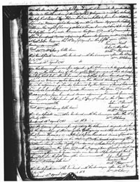
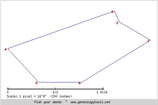
Surveyed for Joseph Tumblestone Junr. 400 Acres of Land in Monongalia County on the Ohio River Opposit Letart Fall Agreeable to a Certificate for Adjusting the Claims to Unpatented Lands in the countys of Monongalia Yohogania & Ohio Including his settlement made thereon in the year 1773 Dat'd 18th. of April in the 5th year of the Common Wealth and Bounded as follows Viz. Beginning at a Beech and Elm on the Bank of the River and Running with the Meanders thereof N 60 degrees W 120 poles Crossing a Run at 44 Poles N 24 W 42 poles from then S 70 1/2 degrees E 380 Poles to a Beach & White Oak S 43 E 154 to a Black Oak E 144 poles to a White Oak N 57 E 262 poles crossing a run to the Beginning. Platted by a scale of 100 poles to the Inch } No Variation. Thomas Evans } David Seare [Sayre] } Sworn Chain Bearers George See Assistant to Sam'l Hanway S.M.C [Surveyor Monongalia County] Footnotes:
1786, May 18 - Land Grant: Joseph Tumblestone, 400 Acres, Letart Joseph Tumblestone, 400 acres, Monongalia. Exd.
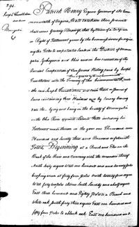
Patrick Henry Esquire Governor of the Commonwealth of Virginia, To all to whom these presents shall come Greeting, Know Ye, that by virtue of a certificate in Right of Settlement given by the Commissioners for adjusting the Titles to unpatented lands in the District of Monongalia, Yohogania and Ohio and in consideration of the Ancient Composition of Two pound Sterling paid by Joseph Tumblestone into the Treasury of this Commonwealth there is granted by the said Commonwealth unto the said Joseph Tumblestone a certain Tract or parcel of land containing Four Hundred acres by survey bearing date the _ lying and being in the County of Monongalia on the Ohio River opposite Letarts Falls including his Settlement made thereon in the year one Thousand seven Hundred and Seventy three and Bounded as followeth, To Wit: Beginning at a Beach and Elm on the Bank of the River and running with the meanders thereof North sixty degrees West one hundred and and twenty poles crossing a run at forty four poles north twenty four degrees West forty two pole thence South Seventy and a half degrees East three hundred and Eighty pole to a Beach and White oak south forth three degrees East one hundred and fifty four poles to a black oak East one hundred and forty four poles to a white oak north fifty Seven degrees East two hundred Sixty two Poles Crossing a run to the Beginning With it appurtenances to have and to hold the said Tract or parcel of land with its appurtenances to the said Joseph Tumblestone and his Heirs for Ever. In Witness whereof the said Partick Henry Esquire Governor of the Commonwealth of Virginia hath hereunto set his Hand and Caused the Lesser Seal of the said Commonwealth to be affixed as Richmond on the Eighteenth Day of May in the year of our Lord one Thousand Seven Hundred & Eighty six and of the Commonwealth the Tenth. P. Henry
Excerpt from Metes and Bounds Prepared and Revised for Use with Deed Platter: N 60 W 120 Excerpt from Metes and Bounds Prepared with Deed Platter Revisions for Transfer to Google Map: 1 Pole = 16.5 feet Beginning at a Beach and Elm on the Bank of the River and running with the meanders thereof North sixty degrees West one hundred and twenty poles crossing a run at forty four poles N 60 degrees W 120 poles crossing a run at 44 poles north twenty four degrees West forty two poles N 24 degrees W 42 poles thence South Seventy and a half degrees East three hundred and Eighty poles to a Beach and White oak S 70.5 degrees E [ W ] 380 poles south forty three degrees East one hundred and fifty four poles to a black oak S 43 degrees E 154 poles East one hundred and forty four poles to a white oak E 144 poles north fifty Seven degrees East two hundred Sixty two Poles Crossing a run to the Beginning N 57 E 260 poles
Sources: Monongalia County, WV, Claims to Unpatented Lands, Microfilm, Page 74, 1781, Apr 18 - Land Entry: Joseph Tombleson, 400 Acres, Letart. View @ Fold3 [ Page 47 ] Monongalia County, WV, Survey Records, Book 3, Page 25, 1783, Sep - Land Survey: Joseph Tumblestone, 400 Acres, Letart. View @ Fold3 [ Page 25 ] Greathouse Point, Greathouse Archives, USA - Mason County, WV. Mapping Big Mill Creek, 1780-1820: Early Landowners of Letart, Millwood and Evans, West Virginia Source: Virginia State Land Office. Grants A-Z, 1-124, reels 42-190; Virginia State Land Office. Grants 125- , reels 369-. Land Office Grants No. 2, 1786, p. 294-295 (Reel 68). 1786, May 18 - Land Grant: Joseph Tumblestone, 400 Acres, Letart. View @ Fold 3 [ Page 294 | Page 295 ] |
||||||
Disclaimer All information submitted to this site remains to the extent the law allows, the property of the submitter who, by submitting it, agrees that it may be freely copied, but never sold or used in a commercial venture without the knowledge and permission of its rightful owner. |
||||||
 |
 |
|
Copyright © 1998 - 2011, Greathouse Point. Terms of Use | Privacy Policy | Site Map |